
Validation Framework for Improving Rice Cultivated Area Statistics
using Japanese Space Technology in Cambodia
Sotheavy Meas1, Men Sothy1, Shoji Kimura2, Kei Oyoshi3 and Shinichi Sobue3
*Department of Planning and Statistics,
Ministry of Agriculture Forestry and Fishery, Cambodia
2 ASEAN+3 Food Security Information System, Thailand
3 Japan Aerospace Exploration Agency, Japan
National agricultural policies are based on statistical data, and the areas under rice cultivation are the most important. The Cambodian Department of Planning and Statistics (DPS), Ministry of Agriculture, Forestry, and Fisheries (MAFF) generates national agricultural statistics by aggregating data collected from local offices using a manual reporting system. However, the accuracies of the reported statistics largely depend on the local officer’s ability to collect the information and objective information are needed to assure the quality of the statistics. Therefore, DPS/MAFF needs additional tools to check the quality of statistics reported by local offices. A project under the Asia-Pacific Regional Space Agency Forum (APRSAF) / Space Applications For Environment (SAFE) Initiative aimed to develop an evidence-based method for this verification (a “Validation Framework”) to improve their statistical accuracy using satellite-derived rice cultivated area.
The Advanced Land Observing Satellite -2 (ALOS-2) PALSAR-2 data (ScanSAR mode) were used to identify rice planted area in this project. ALOS-2 is a Japanese L-band radar satellite launched in May 2014. In Cambodia, rice is planted mainly in rainy season and, some regions are planted both rainy and dry season. Hence, SAR is useful tools to identify rice planted area especially in rainy season. JAXA has developed rice mapping software which utilize machine learning algorithm (random forest) and time-series ALOS-2 ScanSAR data (both HH and HV).
Training dataset for random forest were selected by visual interpretation of Very High Resolution (VHR) satellite images such as Google Earth. More than 2,000 points for rice or non-rice are selected as training data, then randomly selected half of the training data was used for model validation and achieved more than 90% total accuracy. An example seasonal rice planted area map (covering each administrative district) is shown in Figure 1.
a) Spatial distribution of b) Rice-cultivated area for
rice-cultivated areas. (Map) each administrative area (Value)
Figure 1: Information obtained from INAHOR software with ALOS-2 data.
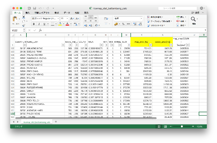
In the validation framework for confirming statistics reported from local offices with above mentioned rice map and area of each administrative districts from ALOS-2, DPS and local office including province and district office work together. DPS and province office edits the information and generates validation sheet (Figure 2) for each commune (minimum unit of the statistics).
The validation sheet enables local officers to easily compare the reported statistics with satellite-derived information. If there is large gap between reported and satellite-based value, reconfirmation activities such as filed verification or additional survey for farmers are conducted, finally rice planted area is fixed.
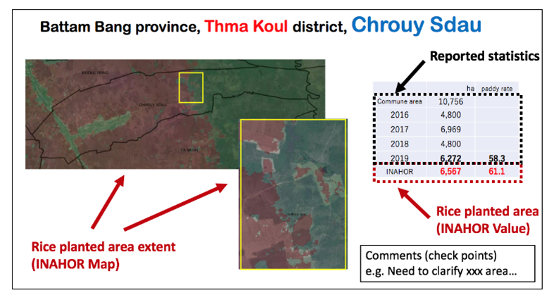
Figure 2: Example of the “Validation Sheet”, which consists of the commune area, reported statistics,
rice planted area and comments for check points.
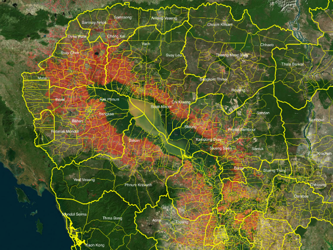
Figure 3 illustrates rice mapping result around Tonle Sap Lake by INAHOR with ALOS-2 data. The demonstration of validation framework for 2019 rainy season rice in Battambang and Kampong Thom province, Cambodia showed that satellite data derived information enabled DPS to verify and improve the statistics. It was found that 37 of the 73 target communes were needed to modify their rice planted area. However, some communes were still reconfirmed as originally reported statistics even if validation framework was conducted (Fig 3). Both planted area collected by satellite measurements and local staffs would have error due to the inherent characteristics of each information collection system, this validation framework complement each other and can improve the rice statistics. Some districts had large differences, but the difference reasons have been cleared by this validation framework, major reasons are limitations of identification from satellite (e.g. many trees inside the paddy field, double cropping in rainy season), or local offices (e.g. planted in conservation area, newly developed cropland).

Figure 3: Rice cultivated area in the 2019 rainy season identified by INAHOR with ALOS-2
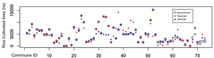
Figure 4: The result of validation framework with satellite based rice cultivated map. White circle means reconfirmed statistics by re-surveying of local staff, red and blue means originally reported from local office, satellite estimation, respectively.
The validation framework using satellite data would be useful tool to validate the rice statistics reported from local office and the demonstration of the framework for 2019 rainy season rice concluded that reported value of some regions should be replaced with refined one. We also prepared the manuals for the validation framework, however further capacity building is a requirement to install the “Validation Framework” in DPS’s operational work. Of course, face-to-face meeting is quite important, but we are now plan to develop e-learning material to share the knowledge efficiently to expand this framework to whole country. In this project, agricultural statistician and remote sensing specialist closely work together, then this Interdisciplinary collaboration enabled us to come up with the validation framework which reconfirm and improve statistics by utilizing validation sheet.
.jpg)
The ASEAN Food Security Information System (AFSIS) Secretariat, in collaboration with the Ministry of Agriculture, Forestry and Fisheries (MAFF) Japan, Japan Aerospace Exploration Agency (JAXA), Remote Sensing Technology Center of Japan (RESTEC), and Geo-Informatics and Space Technology Development Agency (GISTDA), conducted the 2nd Hands-on Training Courses for Agricultural Statisticians, the Final Workshop, and the 2nd Seminar for Executive Officials under the JAIF Project entitled “Improvement of Rice Paddy Area Statistics and Damage Assessment using Earth Observation Satellites for ASEAN” in Sriracha, Chonburi Province, and Bangkok, Thailand.
.jpg)
On 23 April 2026, the AFSIS Secretariat participated in the Ad-Hoc Senior Officials Meeting of the ASEAN Ministers on Agriculture and Forestry (SOM-AMAF), held via a virtual platform, to discuss the implications of recent developments in the Middle East on regional food security and to identify coordinated measures to enhance ASEAN’s food resilience, in preparation for the ASEAN Ministers on Agriculture and Forestry (AMAF) Meeting.

The agricultural sector plays a vital role in supporting food security and livelihoods across ASEAN, where diverse production capacities shape the availability of major agricultural commodities such as rice, maize, sugarcane, soybean, and cassava. This report examines the SSR patterns across ASEAN to emphasize regional strengths, structural imbalances, and the implications for food security and agricultural policy in the region.

The self-sufficiency ratio (SSR) is a key indicator of food security. It shows how well Southeast Asian countries can meet rice demand through domestic production, with the region overall remaining increasingly self-sufficient despite ongoing challenges.

